Retrofit Sites & Recommendations
Methodology
The project team assessed 110 potential stormwater retrofit opportunities at 51 project sites in the watershed. Sites were almost entirely located on the University campus, where the dominant fraction of the watershed’s impervious cover is found. For the town section of the watershed, the focus will be on future development rather than retrofits.
Each of the 51 retrofit opportunities were evaluated using professional judgment and the following technical factors: impervious area treated, pollutant removal capability, runoff reduction estimates, cost, and maintenance requirements. The project team then reviewed the 51 sites with respect to non-technical factors such as feasibility, educational or demonstration potential, and opportunity. Out of these discussions came a “Top Ten” list of priority retrofits, for which the team created 25% design conceptual drawings. The intent is not necessarily to implement these practices exactly as designed, but to inform the design process as building and renovation take place on campus. See project technical report for more information.
Visit the Retrofit Sites Mashup
The mashup is a map that shows the location of each retrofit site using Google Maps. Click on a retrofit balloon to access links to related information for each site. Or, to see a list of sites, view the Eagleville TMDL Project Sites in a larger map.
Watershed Characterization
Watershed Land Cover
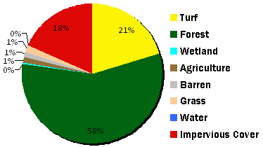
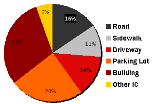
The project team collected datasets on the watershed from both the University and the Town of Mansfield. A detailed land cover map was created by digitizing recent high resolution aerial imagery (below). To give the team a better idea of retrofit opportunities, impervious cover features were also classified by type.
Watershed Impervious cover Estimates and Targets
In July 2009, the project team conducted a four-day field analysis of the watershed. Field work identified important features that could not be determined from the mapping exercise alone. First, the team identified discrepancies in the original watershed boundary as contained in the state hydrography data layer; the revised watershed boundary was about 26 acres less than the original. Second, the team estimated that about 51 acres of the impervious cover in the watershed were effectively disconnected via sheet flow to a large forested area, undetected diversion to another watershed, or through treatment by a recently constructed stormwater practice. Revised impervious cover disconnection targets were made using adjustments which decreased the watershed area by 26 acres, and "removed" 51 acres of disconnected IC.