The Watershed
The Eagleville Brook TMDL was developed as a way to deal with streams impaired by poorly understood urbanization-related impacts. Its location is the Eagleville Brook, which is typical of urban stream syndrome, a complex and synergistic combination of hydrologic alteration and multiple pollutant stressors. The Brook is included on the 2008 list of Connecticut waterbodies not meeting water quality standards based on very low aquatic life use support scores, the causes of which are cited as “unknown.” The Brook has a 2.4 square mile drainage area and flows to an impoundment of the Willimantic River, a tributary of the Thames River basin, which encompasses much of the eastern third of the state. The Eagleville watershed drains a large portion of the University of Connecticut, and for long stretches in the upper part of the watershed the brook is piped underground beneath the campus.
Background
Urbanization
The impervious cover (IC)-TMDL was developed as a pragmatic response to dealing with the often poorly understood impacts of urbanization on stream health. Connecticut is a perfect case study for such an approach, since it is a rapidly urbanizing state. About 238 square miles of the “development footprint,” about 5% of the state, was added from 1985-2006 according to CLEAR’s Connecticut’s Changing Landscape project.
Impervious Cover and Stream Health
Impervious cover has long been recognized as a useful indicator of the impact of watershed land use on the health of the receiving water body. This relationship integrates a complex web of impacts resulting from urbanization. As an indicator, impervious cover has the potential to be widely applied to various land use planning and design scenarios—an approach that has earned both praise and criticism for its simplicity. Visit the Library for more information.
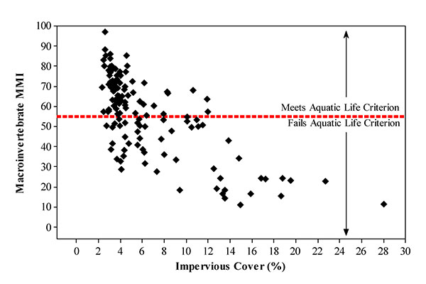
Impervious Cover and Stream Health in Connecticut
In 2005–2006, CT DEEP conducted statewide research comparing stream health, as indicated by metrics for benthic macroinvertebrate populations, to watershed impervious cover estimates provided by CLEAR. A total of 125 stream segments were studied; no stream segment with over 12% impervious cover in its immediate upstream catchment area met the state’s aquatic life criteria for a healthy stream. This became the foundational research supporting the IC-TMDL, which set the IC-TMDL goal as 11% (12% plus a 1% margin of safety).
Project Partners
The Impervious Cover (IC)-TMDL Project is a partnership of the Connecticut Department of Environmental Protection (CT DEEP), the University of Connecticut, and the Town of Mansfield, Connecticut. Not only have all three organizations provided financial support for the project, but all three also have staff involved with the project and with implementation of the TMDL.
Major funding has been provided by CT DEEP’s Clean Water Act Section 319 Nonpoint Source Program and the University of Connecticut. Mansfield also provided support.
CT DEEP TMDL Section
CT DEEP 319 Section
UConn CLEAR
UConn CLEAR NEMO Program
UConn Office of Sustainability
UConn Planning, Design, and Construction
UConn Facilities Operations
UConn Office of Residential Life
Town of Mansfield Planning & Zoning Office
Town of Mansfield Public Works Office
Project Team
The Project Team includes staff from UConn CLEAR’s NEMO Program, the Center for Watershed Protection, and the Horsley Witten Group. CT DEEP staff and staff from UConn Office of Environmental Policy provided assistance to the project team in the field.